NJ Weather: Two Days of Warmth, Cooler By the Weekend
Scattered raindrops and clouds are in the forecast through next week too.
Let the warmup begin! After a cool, grey day on Wednesday, Mother Nature will treat New Jersey to a pair of days with temperatures in the 70s. But it's not going to last long, as the thermometer pendulum swings downward again by the weekend.
Wednesday morning was the coldest of the season so far, with a widespread frost/freeze across about 80% of the state. Thursday morning is a very different picture, with temperatures close to 60 degrees across most of the state. (Far North Jersey is a bit cooler, in the upper 40s to lower 50s.) Patches of fog have been reported, which should burn off by late morning. Additionally, I can't rule out an isolated shower through about 8 a.m. Otherwise, it's a quiet and mild start to the day, and you might get away with skipping the jacket.
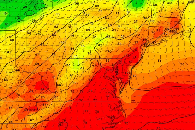
In fact, my Thursday forecast is more optimistic than in the past few days, as skies may very well become partly sunny or even mostly sunny by the afternoon. That will help the warmup — high temperatures will push into the lower 70s. That's about 10 degrees above normal for early November. Yes, it should turn into a beautiful day!
Thursday night will be mild too, as lows only dip into the upper 50s. Clouds will flll back in, although we should remain dry.
Despite mostly cloudy skies, Friday will be warm once again for most of the Garden State. The complication will be an approaching cold front, which could limit warming for the northern part of the state as it arrives as early as mid-afternoon Friday. So, for North Jersey, we'll aim for the mid 60s on Friday. The rest of the state should break into the lower to mid 70s once again.
The aforementioned front could spark a brief shower Friday evening, but it does look mostly dry. Behind the front, colder air will rapidly push temperatures downward, making for a cool Saturday morning in the upper 40s.
Saturday's high temperatures will be limited to about 55 to 60 degrees. Not terrible, but definitely cooler. Skies will remain cloudy.
Another round of scattered showers is modeled for late Saturday through early Sunday. Nothing to write home about in terms of rainfall totals, but there could be a period of soggy weather in the middle of your weekend.
Clouds will continue to win the sky on Sunday, as temperatures moderate to the mid 60s.
The early look at next week doesn't contain much happy news. Monday will be mild, but temperatures look to drop sharply for Tuesday and Wednesday. Along with the cooler temperatures could come periods of rain. Cold rain with cloudy skies and a brisk wind? No thank you.
More From WPG Talk Radio 95.5 FM