
NJ’s soggy March continues: Showers Wednesday, more rain Thursday
The Bottom Line
Surprise, surprise. More wet weather. This month is already in the running to be a top 5 wettest March on record for New Jersey. And we will pad those totals with more raindrops, over the next 36 hours.
A slow-moving front — the dividing line between air masses — will push across New Jersey from Wednesday to Thursday. As disturbances ride along that "highway in the sky," we will get wet. Some of those impulses will produce hit-or-miss showers — especially on Wednesday. Some of those waves will bring steadier, more widespread rain — mainly on Thursday.
Total rainfall will range from about a half-inch west of NJ Turnpike corridor, to 1 to 2 inches along the coast. Definitely wet. And there could be some ponding and flooding issues — a.k.a. "big puddles". But the threat of dramatic flash flooding seems manageable this time around.
Beyond the rain, we will battle some wind on Friday. And then a passing shower is possible Saturday afternoon. The nicest day coming up is actually Easter Sunday, as temperatures potentially warm into the 60s.

Wednesday
Wednesday morning is just fine. Radar is all clear so far. Visibility is good. Skies are mostly cloudy. Winds are calm. And temperatures are comfortably cool, in the lower 40s.
You would be wise to carry an umbrella Wednesday, although you will not need it until later on. Under mostly cloudy skies, spotty rain showers are expected to develop starting in the afternoon hours.
High temperatures should reach the lower 50s Wednesday afternoon. Similar to Tuesday. (Some forecast models push temps in SW NJ closer to 60 degrees, but I think clouds and raindrops will ultimately get in the way of such warmth.)
Showers will carry into Wednesday evening, with steadier rain picking up sometime after Midnight. Low temperatures will dip into the lower 40s.
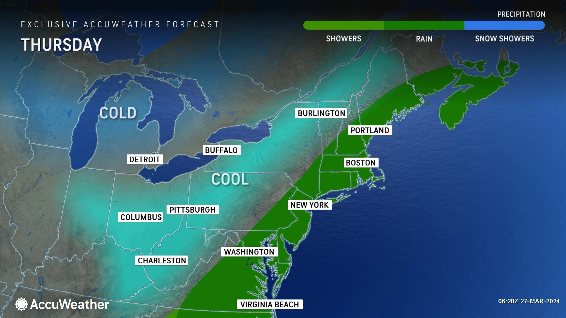
Thursday
Not a pretty weather day. We have settled on a forecast that includes periodic rain for most, including some heavier stuff along the eastern edge of the state. While it does look like an all-day rain event, it is not the kind of drenching the state saw last Saturday, for example.
The steadiest, heaviest rain looks to soak New Jersey Thursday morning, before dialing back a little bit in the afternoon. It is still going to be a wet day overall. The only spot that could see substantial breaks in the rain is that segment of western and northern NJ. (Even so, it will still be cloudy and "blah" all day.)
Temperatures are tricky for Thursday. Again, some models are pumping out 60-degree warmth. I just can not buy into that idea, given the dreary, dismal, cloudy, rainy weather. I've put high temperatures only in the upper 40s.
Final raindrops should fall in New Jersey right around dinnertime, early Thursday evening. And then skies will clear as conditions dry out Thursday night. Temps should stay above freezing, but it will get chilly with many spots in the 30s by Friday morning.
Good Friday
The arrival of a new air mass on Friday will be marked by a "whoosh" of northwesterly wind. Gusts may exceed 30 mph during the day Friday, making things feel pretty blustery.
That is unfortunate, because Friday should turn bright and sunny by midday.
Friday's temperatures will not be dramatically different than the previous few days. Look for highs in the lower 50s.
Saturday
Saturday has one little hiccup: A quick round of passing showers in the forecast for the mid-to-late afternoon hours.
Everything else looks fine. Partly sunny and breezy, with temps slightly above seasonal normals. High temperatures should reach the mid to upper 50s.
Easter Sunday
As I mentioned, it looks like Easter Sunday — the last day of March — will be the nicest and warmest day of the week.
Again, I will call it partly sunny and breezy. Completely dry. The latest forecast puts high temperatures maxing out in the lower 60s.
The Extended Forecast
April will begin where March ends, with seasonably mild and somewhat unsettled weather.
While I can not rule out a shower on Monday, the better rain chance coming down the pike looks to be Tuesday into Wednesday. Once again, not an outright rain storm. Although there could be a wintry component in far northern New Jersey, depending on exact timing and temperatures. Just something to watch for.
Other than occasional spurts of rain, I would expect thermometers to flip-flop between the 50s and 60s through next week at least.
These are among the most movie-ready towns in New Jersey
Gallery Credit: New Jersey 101.5
Dan Zarrow is Chief Meteorologist for Townsquare Media New Jersey. Follow him on Facebook for the latest forecast and realtime weather updates.
20 of the best small towns in New Jersey
Gallery Credit: Dennis Malloy
More From WPG Talk Radio 95.5 FM


![Atlantic City, NJ, Mayor Admits That Chris Christie Was Right [Photos]](http://townsquare.media/site/564/files/2026/04/attachment-resized_screenshot_20260415_123336_chrome.jpeg?w=980&q=75)
![Best Shrimp Cocktail In The Atlantic City, NJ Area [Photos]](http://townsquare.media/site/564/files/2026/04/attachment-img_0483.webp?w=980&q=75)
