Thursday NJ Weather: Pockets of Rain, Some Rumbles of Thunder
The Bottom Line
Let's start off by keeping things in perspective. Summertime is New Jersey's monsoon season, our wet season. While we love sunny, warm days like we saw Wednesday, we also need occasional thunderstorms to keep reservoirs full and plants happy.
So Thursday's rainy forecast is not necessarily a bad thing. Especially since 1.) we will salvage a good part of the day, and 2.) we do not have to ring alarm bells for any crazy severe weather this time around.
The most widespread thunderstorm activity on Thursday will arrive during the afternoon hours. There could be some heavy stuff at times, forming big puddles and slowing you down.
Thursday night, our weather will dry out and clear out again, setting up a fantastic Friday.
The weekend turns unsettled again, with some popup thunderstorms in play. More noticeable may be the steamy weather conditions though, as humidity surges again and temperatures end up close to 90 degrees.

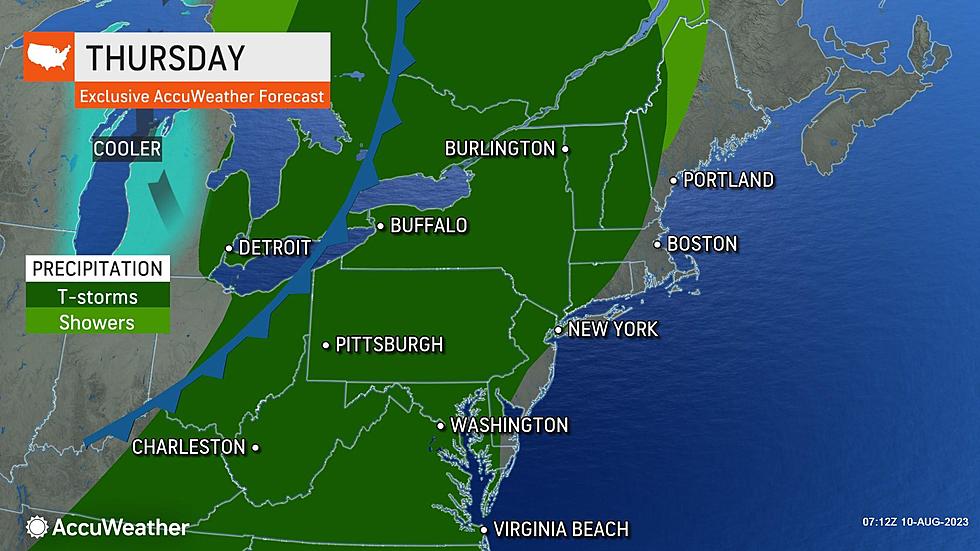
Thursday
Thursday will not be the prettiest day. But, as you will notice Thursday morning, it will not be a total washout.
We are starting the day with increasing clouds and comfortable temperatures, mainly in the 60s. As of this writing (6:30 a.m.), there are rain showers hovering about 50 miles west of New Jersey. They're coming — eventually.
I think NJ's first raindrops will creep across the Delaware River around late morning. Let's say 10 or 11 a.m.
We will hit our high temperature for the day just before the rain begins, in the upper 70s to lower 80s. It is going to feel a bit stickier and more humid, as dew points rise well into the 60s again.
The "epicenter" of rain for Thursday will be in the afternoon hours. That is the time of the most widespread rain. And also the greatest risk for localized downpours and embedded thunderstorms.
The severe weather parameters are not coming together for big wind, hail, or tornado problems. It's really just going to be some scattered rain, on the order of a quarter-inch to half-inch. Heavier pockets of rain may exceed an inch, possibly enough to cause some ponding and flooding issues.

As the sun starts to set Thursday evening, rain showers will exit the Garden State. And skies will quickly clear. So you may be able to salvage dry weather for part of the evening too.
Humidity will dial back again Thursday night, allowing for comfortable low temperatures in the mid 60s by Friday morning.
Friday
Once again, I have no hesitation in calling Friday another beautiful summer day.

Skies will start mostly sunny, with some additional cloud cover building. Dew points may dip into the 50s, making the air comfortable. And our weather will stay completely dry.
Look for high temperatures in the mid 80s for most. Just like Wednesday, I wouldn't rule out a 90-degree reading here or there.
Saturday
I would not go so far as to dub this weekend "steamy and stormy". Yes, there will be some isolated pockets of rain. Yes, humidity and temperatures will climb. But as I have discussed so many times recently, that is what August weather is all about in New Jersey.
Saturday will start with a mix of sun and clouds. High temperatures will push into the upper 80s to around 90 degrees.
A few popup showers and thunderstorms are possible during the peak heating hours Saturday, between about mid-afternoon and early evening. They will be spotty, hit-or-miss popcorn storms. But a brief downpours and some lightning could be a quick pause to any outdoor festivities.

Sunday
Sunday looks almost exactly the same as Saturday, only hotter and more humid.
With a high temperature around 90 degrees and dew points probably well into the 70s, the heat index ("feels like" or "apparent" temperature) may climb into the mid to upper 90s. That is pretty uncomfortable. Not quite "dangerous" heat, but certain well above midsummer normals.
For Sunday, I would say a shower or thunderstorm is possible at any time, not just limited to the late-day period. But again, they will be isolated.
The Extended Forecast
The next substantial storm system to worry about will be a cold front arriving late Monday. A round of thunderstorms and heavy rain will eventually usher in calmer, more comfortable weather. At the moment, Tuesday and Wednesday look like delightful weather days.
12 Things You Should NEVER Recycle
Gallery Credit: Boris
NJ's Top 3 Safest and Most Dangerous Car Brands
Gallery Credit: Heather DeLuca
More From WPG Talk Radio 95.5 FM


