Oh Right, it’s February: Cold and Ice Return to NJ Thursday
The Bottom Line
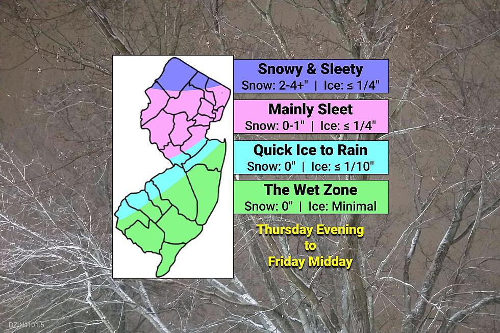
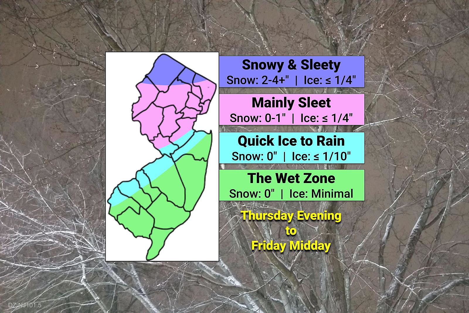
Cold air has returned. Meanwhile, our next weather maker, arriving Thursday night into Friday, will NOT be a "snow" storm for New Jersey. In fact, for the southern half of the state, it's going to be almost exclusively rain. The farther north and west you are, the higher the risk of slippery roads, mainly due to sleet and freezing rain.
This is the only substantial storm system in view, through the rest of February. Having said that, we have some real "weather whiplash" ahead — each day will be significantly warmer or colder than the day before.
Timeline
—Appetizer... An initial piece of energy will spark some spotty showers during the daytime hours Thursday. That will mainly affect the southern half of the state. And it will be mixed precipitation — mainly snow and sleet, with some rain to the south. (Of course, it depends on the exact air temperature at the time.) Since the ground is so warm and precipitation intensity will be rather light, I am not worried about widespread accumulations and travel headaches.

—Start... The "main event," with a block of widespread wintry mix precipitation, will slide into New Jersey Thursday evening. Possibly as early as 7 or 8 p.m.
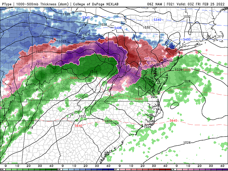
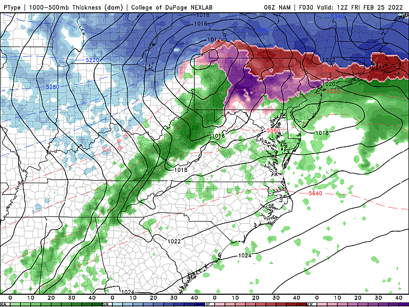
—Brunt... The steadiest, heaviest precip will occur overnight through early Friday morning, from about 11 p.m. to 9 a.m. Note that temperatures (both aloft and at the surface) will slowly rise during this time, so a transition from sleet/freezing rain to plain rain will progress from south to north. Most of the state will be wet, not wintry, by daybreak Friday.
—End... The final piece of wintry mix (north) and rain (most) will clear the state early Friday afternoon. Skies will then clear, with breezy conditions and seasonable temperatures pushing into the 40s.
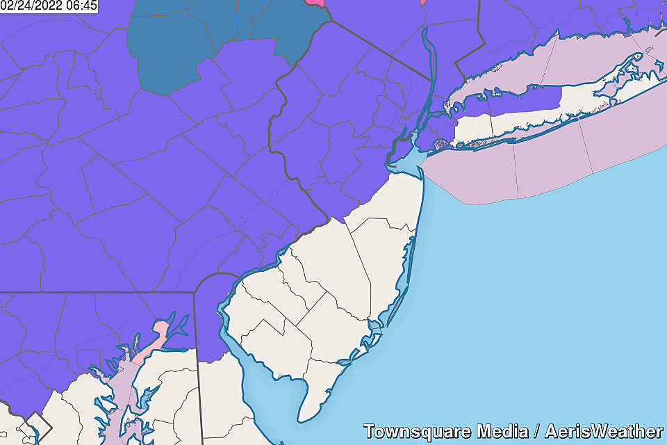
The Wet Zone: South & Coast
This is the "green" area on my forecast map above. Almost all rain — sorry kiddies, you're going to have a full day of school (and work) on Friday. There could be a brief period (an hour or two) of sleet as things get started Thursday evening. And then, it'll just be rain, rain, rain for the duration.
Quick Ice to Rain: I-295 and Route 1 Corridor
The "light blue" color on my forecast map. The initial period of sleet and (primarily) freezing rain could be a bit more impactful than areas closer to the coast. But we'll flip to plain rain before the brunt of the storm begins overnight. So there could be some icy spots here Thursday evening. But by Friday morning's commute, you'll only be dodging puddles. The liquid kind.
Mainly Sleet: Northwest of the Turnpike
"Pink" on the map above. Here is where things may get especially icy and dicey. While you might see an initial period of snow Thursday evening, sleet will be the predominant precipitation type. Those ice pellets will be knocking on your windows through the overnight hours all the way into Friday morning's commute. There will be a transition eventually, but that may not happen until after daybreak.
Keep in mind, sleet does not accumulate like fluffy snow does. And it's slippery, but not as perilous as freezing rain. So nailing down the exact impacts in this area of the state is tricky. I do expect some school delays and even closings on Friday — superintendents and administrators would be wise to wait until the morning to assess conditions and make that local decision.
Snowy and Sleety: Far Northern New Jersey
The "blue" color along the northern edge of New Jersey. The only place in the state likely to stay below freezing for the duration of the storm. So it's the only place that could see substantial snowfall. Latest models are very consistent keeping any risk of heavy snow (6 to 8+ inches) north and west of New Jersey. But still, 2 to 4+ inches of snow is shovelable and possibly plowable. And there's a reasonably icing threat on top of that, due to sleet and freezing rain at the end of the storm. (Several forecasts are slightly higher than mine, but I'm betting on more sleet than snow getting involved.)
Winter Weather Advisory
NWS nailed it on the geography and messaging with this Winter Weather Advisory, issued for a total of 12 counties in northern and central New Jersey.
—From 7 p.m. Thursday to 10 a.m. Friday... Mercer and Middlesex counties.
—From 7 p.m. Thursday to 1 p.m. Friday... Bergen, Essex, Hudson, Hunterdon, Morris, Passaic, Somerset, Sussex, Union, and Warren counties.
An "advisory-level" event cautions of treacherous travel conditions. But not as hazardous (or impossible) as a warning. Consider it a formal "heads up" to messy weather.
The Extended Forecast
Another burst of cold air arrives for the start of the weekend. Saturday looks partly sunny and dry. 20s in the morning. Only lower-mid 30s in the afternoon.
Sunday will easily be the warmer day of the weekend, in the seasonable 40s. I've removed previous chances of showers which look to stay away from NJ. In their absence, sunshine and breezy conditions will prevail.
Then Monday will flip-flop back to bitterly cold weather. Probably the coldest of the week, in fact. Teens in the morning, with the wind chill possibly dipping to zero. And afternoon highs may struggle to even reach the freezing mark.
While there are no significant storm systems in sight for the next week, we can't let our guard down. March can be a notoriously violent month of weather, as warmer air classes with colder air, and winter breathes its last gasp. Don't think we're done with snow and ice just yet.
MORE WEATHER: Why an ice storm is different from a snow storm
COZY: New Jersey's Favorite Romcoms
More From WPG Talk Radio 95.5 FM


